

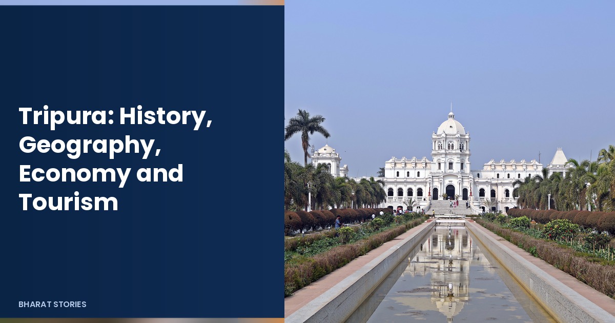
 Photo: Kingshuk Mondal, CC BY 4.0, via Wikimedia Commons
Tripura: History, Geography, Economy and Tourism
Tripura is a small, green state in northeast India, almost surrounded by Bangladesh on three sides, with Assam and Mizoram as its Indian neighbours. Hills, bamboo groves and river valleys shape the land, and Agartala, the capital, is the main city and gateway. For regional context, see our profile of neighbouring Assam.
This updated profile covers Tripura’s history, geography, government, economy and tourism, with details checked for November 2026. The old version of this page was short and hard to use, so it has been rewritten in full.
Table of Contents
Tripura at a Glance
| Item | Detail |
|---|---|
| Capital | Agartala |
| Area | About 10,492 square km |
| Population | 36,73,917 (Census 2011) |
| Statehood | 21 January 1972 |
| Districts | 8 |
| Chief Minister | Prof. (Dr.) Manik Saha |
| Governor | Indrasena Reddy Nallu (since October 2023) |
| Legislature | 60 seat assembly; 2 Lok Sabha seats |
| Main languages | Bengali, Kokborok and others |
History of Tripura
The Manikya kingdom
For centuries Tripura was ruled by the Manikya dynasty. Court chronicles and later histories describe a kingdom that dealt with neighbouring hill peoples and with larger powers in Bengal. Agartala grew as a royal centre. Ujjayanta Palace, built in the early twentieth century under Maharaja Radha Kishore Manikya, remains the best known landmark of that era and now houses the state museum.
From princely state to Indian state
After Indian independence, Tripura joined the Indian Union as a princely state and later became a Union Territory. On 21 January 1972 it became a full state. The decades around Partition and later years also brought large movements of people across the border with what is now Bangladesh, which shaped the state’s language mix and politics.
Culture and people
Tripura’s population includes Bengali speaking communities and many indigenous groups, among them the Tripuri (or Tipra) people, whose language Kokborok has official recognition alongside Bengali. Folk dances, bamboo crafts and festivals such as Garia and Kharchi are part of local life. Readers looking at study options in the state can also see our list of approved distance education universities in Tripura.
Geography
Hills and rivers
Most of Tripura is low hills and valleys rather than high mountains. Several parallel hill ranges run roughly north to south, with rivers such as the Gomati, Howrah and Manu draining the land. Rainfall is heavy in the monsoon, and the climate is humid for much of the year.
Borders and location
The long border with Bangladesh makes Tripura a sensitive and busy frontier state. Road and trade links through Assam connect it to the rest of India. The state is small in area compared with giants such as Rajasthan or Madhya Pradesh, but its position gives it strategic and cultural importance in the northeast. For another small hill state profile, see Sikkim.
Wildlife and forests
Forests still cover a large share of the land. Clouded leopards, elephants in some pockets, many birds and rich plant life are part of the natural heritage. Protected areas and lake wetlands near Agartala draw visitors who want quiet nature rather than crowded city sightseeing.
Administrative divisions
Tripura is divided into 8 districts, with Agartala in West Tripura as the main urban centre. Smaller towns serve the hill and valley blocks. Local government and autonomous district structures also matter for indigenous areas.
Government and Politics
The state has a 60 member legislative assembly and sends 2 members to the Lok Sabha. Prof. (Dr.) Manik Saha has been Chief Minister, and Indrasena Reddy Nallu has served as Governor since 26 October 2023. As in other northeast states, parties and alliances have shifted over the years, and development, identity and border management remain central themes.
Economy
Agriculture and rubber
Farming and allied work support many families. Tripura is among India’s leading rubber growing states. Tea, bamboo, fruit and fisheries also matter. Natural gas production adds an energy strand to the economy.
Industry and services
Small industry, handicrafts and services in Agartala form the urban economy. Handloom and bamboo products are sold within India and sometimes abroad. Connectivity by road and air has improved over the past decade, which helps trade and tourism.
Tourism
Tourism is still smaller than in Goa or Rajasthan, but it is growing around heritage, lakes and temples. Visitors often combine Agartala with nearby nature spots rather than treating the state as a single monument stop.
Top Places to Visit
- Ujjayanta Palace and museum: the former royal palace in Agartala, set in gardens, now a museum of Tripura’s history and culture.
- Neermahal: a water palace on a lake at Melaghar, built by a Manikya ruler as a summer retreat.
- Unakoti: rock cut faces and sculptures in a forested setting, important for Shaiva heritage.
- Sepahijala Wildlife Sanctuary: a nearby green space with a zoo and lake for day trips from Agartala.
- Tripura Sundari Temple at Udaipur: one of the state’s major temples and a pilgrimage stop.
- Jampui Hills: a quieter hill belt known for views and orange orchards.
October to March is usually the most comfortable season for travel. Carry rain protection in the monsoon months.
People and Culture
Bengali and Kokborok literature, music and theatre share space in public life. Rice based meals, freshwater fish and bamboo shoots appear often in local cooking. Handloom cloth and bamboo craft make practical souvenirs. Respect for temple and community festival rules helps visitors fit in smoothly.
Travel Practicalities in Tripura
Most visitors fly into Agartala or arrive by road through Assam. Hotels cluster in the capital, with simpler stays near lakes and temple towns. Carry identity documents for hotel check in, as elsewhere in India. Card payments work in larger hotels; smaller shops may prefer cash.
Bengali and Hindi are widely understood in Agartala; Kokborok appears in many indigenous areas. Learning a few polite greetings helps. Temple dress codes are modest. Ask before photographing people at close range during rituals.
Food leans on rice, fish and seasonal vegetables. Drinking bottled or filtered water is the safer choice for travellers. Monsoon humidity is high; light cotton clothing and mosquito protection make outdoor evenings easier.
Day trips to Neermahal, Sepahijala and Unakoti are realistic from Agartala with a hired car. Jampui Hills needs more time and flexible plans if mist closes views. Combine Tripura with Assam or a Bangladesh border story only through legal crossing points and proper papers; casual border wandering is not allowed.
Handloom markets sell fabrics and bamboo craft. Compare prices and quality, and be wary of claims that every piece is rare antique work. Supporting artisan cooperatives helps money reach makers directly.
Mobile data coverage is decent in the capital and patchier in remote hills. Download offline maps. During heavy rain, hill roads can slow or close; build slack into return flights.
Students and working professionals also come for colleges and government offices. Our linked list of distance education options is one starting point for academic planning, not a ranking.
Handwritten history boards in museums reward slow reading. School groups visit Unakoti and the palace museum on weekdays, so early mornings are quieter for photography.
Bamboo bridges and rural paths can be slippery after rain; wear shoes with grip. Ask villagers before flying drones near homes or temples.
State tourism offices publish current event calendars. Checking them avoids clashes with road closures for processions.
Tripura’s compact size means you can see several highlights in three to four days without rushing every hour, if weather cooperates.
Frequently Asked Questions
Who is the Chief Minister of Tripura in 2026?
Prof. (Dr.) Manik Saha.
Who is the Governor of Tripura?
Indrasena Reddy Nallu, in office since 26 October 2023.
When did Tripura become a full state?
On 21 January 1972.
How many districts does Tripura have?
8 districts.
What is Tripura best known for in the economy?
Among other things, it is a major rubber growing state and also produces tea, bamboo goods and natural gas.
Agartala airport and road links through Assam are the usual ways visitors reach the state.
Border haats and regulated trade points with Bangladesh matter for some local markets.
Cloud and mist are common in the hills, so outdoor plans should stay flexible in the rains.
Kokborok language signage appears alongside Bengali in many public places.
Students from Tripura also travel to universities in other northeast states and to Delhi.
Light cotton clothes work for much of the year; a light jacket helps in cooler hill evenings.
Ask locally before photographing inside temples or during community rituals.
Carry cash for smaller towns where card machines may be limited.
Agartala bookshops and cafes are good places to ask about current local exhibitions.
Rubber plantation belts are working landscapes; ask before entering private paths.
Evening lights at Ujjayanta Palace gardens are popular; carry a light jacket in winter.
Shared sumos run some inter district routes; confirm the destination before boarding.
Festival dates follow local calendars; hotels fill when major celebrations land.